


R2-SA FORÊT DE MEUDON

CSR-94
User
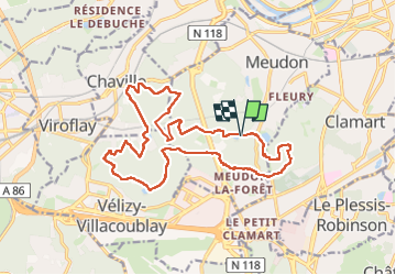

Length
18.3 km

Max alt
187 m

Uphill gradient
368 m
Km-Effort
23 km

Min alt
109 m

Downhill gradient
370 m
Boucle
Yes
Creation date :
2025-04-27 21:58:51.801
Updated on :
2025-04-27 22:09:41.048
5h16
Difficulty : Very difficult

FREE GPS app for hiking
 SityTrail
IGN / Geographical institutes
SityTrail Plus
The world is yours!
About
Trail Walking of 18.3 km to be discovered at Ile-de-France, Hauts-de-Seine, Meudon. This trail is proposed by CSR-94.

Positioning
Country:
France
Region :
Ile-de-France
Department/Province :
Hauts-de-Seine
Municipality :
Meudon
Location:
Unknown
Start:(Dec)
Start:(UTM)
443271 ; 5405236 (31U) N.
Comments