


2025-04-28_11h37m56_SityTrail - 2848126 - fouday-promont-

Domlouise
User
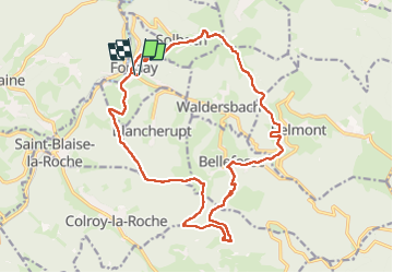

Length
19.8 km

Max alt
875 m

Uphill gradient
702 m
Km-Effort
29 km

Min alt
399 m

Downhill gradient
702 m
Boucle
Yes
Creation date :
2025-04-28 09:37:57.171
Updated on :
2025-04-28 09:37:59.397

FREE GPS app for hiking
 SityTrail
IGN / Geographical institutes
SityTrail Plus
The world is yours!
About
Trail of 19.8 km to be discovered at Grand Est, Bas-Rhin, Fouday. This trail is proposed by Domlouise.
Positioning
Country:
France
Region :
Grand Est
Department/Province :
Bas-Rhin
Municipality :
Fouday
Location:
Unknown
Start:(Dec)
Start:(UTM)
365958 ; 5364587 (32U) N.
Comments