


Test

alternatives-wandern
User
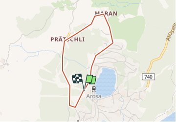

Length
3.1 km

Max alt
1902 m

Uphill gradient
152 m
Km-Effort
5.1 km

Min alt
1743 m

Downhill gradient
148 m
Boucle
Yes
Creation date :
2014-12-10 00:00:00.0
Updated on :
2014-12-10 00:00:00.0
1h15
Difficulty : Unknown

FREE GPS app for hiking
 SityTrail
IGN / Geographical institutes
SityTrail Plus
The world is yours!
About
Trail Other activity of 3.1 km to be discovered at Grisons, Plessur, Arosa. This trail is proposed by alternatives-wandern.
Positioning
Country:
Switzerland
Region :
Grisons
Department/Province :
Plessur
Municipality :
Arosa
Location:
Unknown
Start:(Dec)
Start:(UTM)
551735 ; 5181352 (32T) N.
Comments