


2025-04-29_21h42m40_SityTrail - 3666741 - crouttesxsurxmarne-du-20x05x2023

explorateur
User
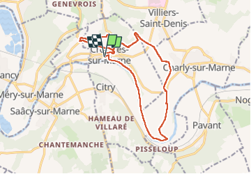

Length
14.7 km

Max alt
175 m

Uphill gradient
204 m
Km-Effort
17.4 km

Min alt
52 m

Downhill gradient
204 m
Boucle
Yes
Creation date :
2025-04-29 19:42:46.11
Updated on :
2025-04-29 19:42:50.958

FREE GPS app for hiking
 SityTrail
IGN / Geographical institutes
SityTrail Plus
The world is yours!
About
Trail of 14.7 km to be discovered at Hauts-de-France, Aisne, Crouttes-sur-Marne. This trail is proposed by explorateur.
Positioning
Country:
France
Region :
Hauts-de-France
Department/Province :
Aisne
Municipality :
Crouttes-sur-Marne
Location:
Unknown
Start:(Dec)
Start:(UTM)
517421 ; 5425120 (31U) N.
Comments