


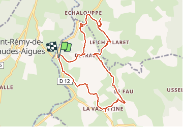
LA CHALDETTE 48 - Le Fau - Le Truc du Cheylaret - Reyrac

jeff66
User


2h44
Difficulty : Medium

FREE GPS app for hiking
 SityTrail
IGN / Geographical institutes
SityTrail Plus
The world is yours!
About
Trail Walking of 10.5 km to be discovered at Occitania, Lozère, Brion. This trail is proposed by jeff66.
Description
LA CHALDETTE 48 - D12 - la Prugne - Puech de la Chios - la Valentine - le Fau - Reyrac - le Cheylaret - rocher du Cheylaret vierge table d'orientation - vue panoramique a 360 degrés - GR de pays du tour des monts d'Aubrac - vue sur le truc du Cheylaret - Reyrac -
Photos


24 photos in total. Please click on a photo to see them all in the gallery.
Positioning
Comments