Hänsches 2

FlorieAnne
User
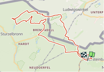

Length
24 km

Max alt
366 m

Uphill gradient
433 m
Km-Effort
30 km

Min alt
241 m

Downhill gradient
432 m
Boucle
Yes
Creation date :
2025-05-01 08:30:35.368
Updated on :
2025-05-01 08:31:05.836
0m
Difficulty : Very easy

FREE GPS app for hiking
 SityTrail
IGN / Geographical institutes
SityTrail Plus
The world is yours!
About
Trail Coupling of 24 km to be discovered at Grand Est, Bas-Rhin, Obersteinbach. This trail is proposed by FlorieAnne.
Positioning
Country:
France
Region :
Grand Est
Department/Province :
Bas-Rhin
Municipality :
Obersteinbach
Location:
Unknown
Start:(Dec)
Start:(UTM)
403384 ; 5432235 (32U) N.
Comments