


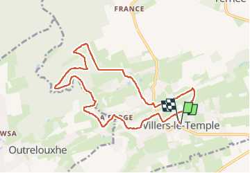
villers le temple
© OpenStreetMap contributors


2h19
Difficulty : Medium


Length
8.9 km
Max alt
240 m
Uphill gradient
170 m
Km-Effort
11.1 km
Min alt
181 m
Downhill gradient
171 m
Boucle
Yes
Creation date :
2025-05-01 06:43:39.481
Updated on :
2025-05-01 09:18:29.232
2h19
Difficulty : Medium
FREE GPS app for hiking
 SityTrail
IGN / Geographical institutes
SityTrail Plus
The world is yours!
About
Trail Walking of 8.9 km to be discovered at Wallonia, Liège, Nandrin. This trail is proposed by houetphilippe@gmail.com.
Description
facile
Positioning
Country:
Belgium
Region :
Wallonia
Department/Province :
Liège
Municipality :
Nandrin
Location:
Unknown
Start:(Dec)
Start:(UTM)
668099 ; 5597823 (31U) N.
Comments