


Muguet

charpe
User
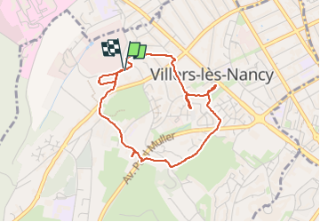

Length
3.9 km

Max alt
298 m

Uphill gradient
79 m
Km-Effort
4.9 km

Min alt
231 m

Downhill gradient
80 m
Boucle
Yes
Creation date :
2025-05-01 08:19:44.0
Updated on :
2025-05-01 09:51:08.144
1h20
Difficulty : Easy

FREE GPS app for hiking
 SityTrail
IGN / Geographical institutes
SityTrail Plus
The world is yours!
About
Trail Walking of 3.9 km to be discovered at Grand Est, Meurthe-et-Moselle, Villers-lès-Nancy. This trail is proposed by charpe.
Positioning
Country:
France
Region :
Grand Est
Department/Province :
Meurthe-et-Moselle
Municipality :
Villers-lès-Nancy
Location:
Unknown
Start:(Dec)
Start:(UTM)
289843 ; 5395077 (32U) N.
Comments