


jpaul77

jpaul77
User
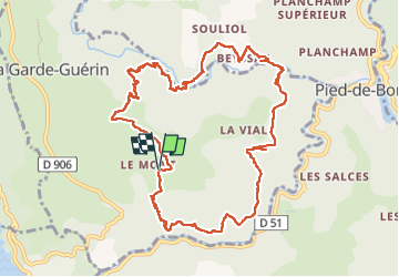

Length
12.6 km

Max alt
860 m

Uphill gradient
693 m
Km-Effort
22 km

Min alt
368 m

Downhill gradient
691 m
Boucle
Yes
Creation date :
2025-04-30 07:46:39.969
Updated on :
2025-05-01 11:44:23.937
6h57
Difficulty : Very difficult

FREE GPS app for hiking
 SityTrail
IGN / Geographical institutes
SityTrail Plus
The world is yours!
About
Trail Walking of 12.6 km to be discovered at Occitania, Lozère, Prévenchères. This trail is proposed by jpaul77.
Description
rando très difficile mais des vues magnifiques sur les gorges de la Borne et du Chassezac.
A faire absolument mais il faut être bien entraîné.
Positioning
Country:
France
Region :
Occitania
Department/Province :
Lozère
Municipality :
Prévenchères
Location:
Unknown
Start:(Dec)
Start:(UTM)
575746 ; 4924128 (31T) N.
Comments