


JLR AUBUSSARGUES

papirabbit
User
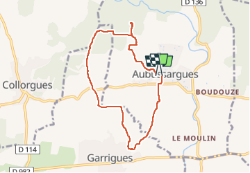

Length
7.6 km

Max alt
216 m

Uphill gradient
134 m
Km-Effort
9.4 km

Min alt
103 m

Downhill gradient
136 m
Boucle
Yes
Creation date :
2025-05-01 11:23:12.0
Updated on :
2025-05-01 13:35:19.157

FREE GPS app for hiking
 SityTrail
IGN / Geographical institutes
SityTrail Plus
The world is yours!
About
Trail of 7.6 km to be discovered at Occitania, Gard, Aubussargues. This trail is proposed by papirabbit.
Description
7 6 km 2h10
Positioning
Country:
France
Region :
Occitania
Department/Province :
Gard
Municipality :
Aubussargues
Location:
Unknown
Start:(Dec)
Start:(UTM)
606054 ; 4873497 (31T) N.
Comments