


2025-05-01_19h07m44_visorando-autour-du-port-de-plaisance-de-port-la-foret

bstebe
User
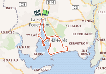

Length
5.9 km

Max alt
13 m

Uphill gradient
37 m
Km-Effort
6.4 km

Min alt
0 m

Downhill gradient
39 m
Boucle
Yes
Creation date :
2025-05-01 17:07:44.369
Updated on :
2025-05-01 17:07:44.215

FREE GPS app for hiking
 SityTrail
IGN / Geographical institutes
SityTrail Plus
The world is yours!
About
Trail of 5.9 km to be discovered at Brittany, Finistère, La Forêt-Fouesnant. This trail is proposed by bstebe.
Positioning
Country:
France
Region :
Brittany
Department/Province :
Finistère
Municipality :
La Forêt-Fouesnant
Location:
Unknown
Start:(Dec)
Start:(UTM)
426895 ; 5306670 (30T) N.
Comments