


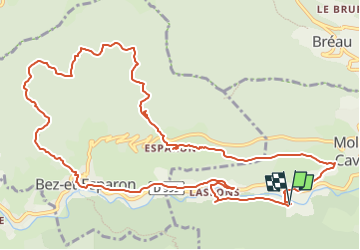
La boucle d'Esparon

ARVIEU
User

Length
14.2 km

Max alt
635 m

Uphill gradient
553 m
Km-Effort
22 km

Min alt
260 m

Downhill gradient
551 m
Boucle
Yes
Creation date :
2025-05-02 05:50:53.477
Updated on :
2025-05-02 05:51:56.845
5h30
Difficulty : Medium

FREE GPS app for hiking
 SityTrail
IGN / Geographical institutes
SityTrail Plus
The world is yours!
About
Trail Walking of 14.2 km to be discovered at Occitania, Gard, Molières-Cavaillac. This trail is proposed by ARVIEU.
Description
Au départ de Molières-Cavaillac (parking de la voie verte), montée vers Esparon puis redescente vers Bez, puis Lasfons et par la voie verte.
Points of interest


Positioning
Country:
France
Region :
Occitania
Department/Province :
Gard
Municipality :
Molières-Cavaillac
Location:
Unknown
Start:(Dec)
Start:(UTM)
545362 ; 4868561 (31T) N.
Comments