


babette

cherlieu
User

Length
21 km

Max alt
998 m

Uphill gradient
760 m
Km-Effort
31 km

Min alt
564 m

Downhill gradient
759 m
Boucle
Yes
Creation date :
2025-04-29 07:07:40.497
Updated on :
2025-05-02 07:02:45.692
8h55
Difficulty : Difficult

FREE GPS app for hiking
 SityTrail
IGN / Geographical institutes
SityTrail Plus
The world is yours!
About
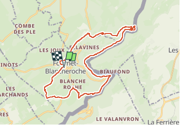
Trail Walking of 21 km to be discovered at Bourgogne-Franche-Comté, Doubs, Fournet-Blancheroche. This trail is proposed by cherlieu.
Positioning
Country:
France
Region :
Bourgogne-Franche-Comté
Department/Province :
Doubs
Municipality :
Fournet-Blancheroche
Location:
Unknown
Start:(Dec)
Start:(UTM)
335136 ; 5226130 (32T) N.
Comments