


fin bord de seine 3035 06 03

pablo92
User
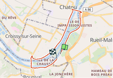

Length
7.3 km

Max alt
35 m

Uphill gradient
64 m
Km-Effort
8.2 km

Min alt
17 m

Downhill gradient
64 m
Boucle
No
Creation date :
2025-05-02 09:31:27.994
Updated on :
2025-05-02 11:43:58.554
2h11
Difficulty : Medium

FREE GPS app for hiking
 SityTrail
IGN / Geographical institutes
SityTrail Plus
The world is yours!
About
Trail Walking of 7.3 km to be discovered at Ile-de-France, Hauts-de-Seine, Rueil-Malmaison. This trail is proposed by pablo92.
Positioning
Country:
France
Region :
Ile-de-France
Department/Province :
Hauts-de-Seine
Municipality :
Rueil-Malmaison
Location:
Unknown
Start:(Dec)
Start:(UTM)
437900 ; 5413646 (31U) N.
Comments