


2025-05-02_15h03m02_tours_d_omigna_et_d_orchinu-17418488-1746190419-594

XavierFaidix
User
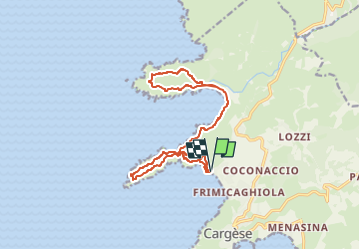

Length
17.2 km

Max alt
165 m

Uphill gradient
476 m
Km-Effort
24 km

Min alt
-1 m

Downhill gradient
462 m
Boucle
Yes
Creation date :
2025-05-02 13:03:02.885
Updated on :
2025-05-02 13:03:02.668

FREE GPS app for hiking
 SityTrail
IGN / Geographical institutes
SityTrail Plus
The world is yours!
About
Trail of 17.2 km to be discovered at Corsica, South Corsica, Cargèse. This trail is proposed by XavierFaidix.
Positioning
Country:
France
Region :
Corsica
Department/Province :
South Corsica
Municipality :
Cargèse
Location:
Unknown
Start:(Dec)
Start:(UTM)
465994 ; 4666535 (32T) N.
Comments