


La Mangeoï (Beauvezer 04)

Clo0413
User
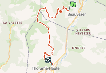

Length
14.9 km

Max alt
2029 m

Uphill gradient
753 m
Km-Effort
26 km

Min alt
1122 m

Downhill gradient
925 m
Boucle
No
Creation date :
2025-05-02 06:59:03.108
Updated on :
2025-05-03 17:17:15.486
4h28
Difficulty : Difficult

FREE GPS app for hiking
 SityTrail
IGN / Geographical institutes
SityTrail Plus
The world is yours!
About
Trail Walking of 14.9 km to be discovered at Provence-Alpes-Côte d'Azur, Alpes-de-Haute-Provence, Beauvezer. This trail is proposed by Clo0413.
Positioning
Country:
France
Region :
Provence-Alpes-Côte d'Azur
Department/Province :
Alpes-de-Haute-Provence
Municipality :
Beauvezer
Location:
Unknown
Start:(Dec)
Start:(UTM)
306693 ; 4890940 (32T) N.
Comments