


Luberon étape 4 faite

dblix
User

Length
25 km

Max alt
553 m

Uphill gradient
837 m
Km-Effort
36 km

Min alt
101 m

Downhill gradient
888 m
Boucle
No
Creation date :
2025-05-02 07:20:47.0
Updated on :
2025-05-02 16:10:23.906
4h51
Difficulty : Very difficult

FREE GPS app for hiking
 SityTrail
IGN / Geographical institutes
SityTrail Plus
The world is yours!
About
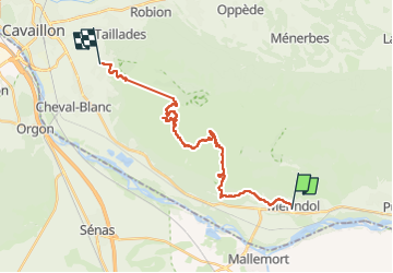
Trail Walking of 25 km to be discovered at Provence-Alpes-Côte d'Azur, Vaucluse, Mérindol. This trail is proposed by dblix.
Positioning
Country:
France
Region :
Provence-Alpes-Côte d'Azur
Department/Province :
Vaucluse
Municipality :
Mérindol
Location:
Unknown
Start:(Dec)
Start:(UTM)
677204 ; 4846902 (31T) N.
Comments