


GR5-Briançon-Menton - 6

cron
User
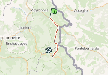

Length
19.8 km

Max alt
2670 m

Uphill gradient
1226 m
Km-Effort
35 km

Min alt
1675 m

Downhill gradient
1023 m
Boucle
No
Creation date :
2017-03-05 00:00:00.0
Updated on :
2017-03-05 00:00:00.0
7h14
Difficulty : Difficult

FREE GPS app for hiking
 SityTrail
IGN / Geographical institutes
SityTrail Plus
The world is yours!
About
Trail Walking of 19.8 km to be discovered at Provence-Alpes-Côte d'Azur, Alpes-de-Haute-Provence, Val-d'Oronaye. This trail is proposed by cron.
Positioning
Country:
France
Region :
Provence-Alpes-Côte d'Azur
Department/Province :
Alpes-de-Haute-Provence
Municipality :
Val-d'Oronaye
Location:
Larche
Start:(Dec)
Start:(UTM)
328731 ; 4924169 (32T) N.
Comments