


entre le Font du Griffe et Pégairolles de Buèges

Lionel Verdoucq 2
User
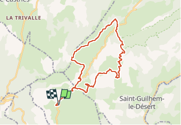

Length
19.4 km

Max alt
769 m

Uphill gradient
611 m
Km-Effort
28 km

Min alt
329 m

Downhill gradient
612 m
Boucle
Yes
Creation date :
2025-05-03 07:04:59.462
Updated on :
2025-05-03 11:23:34.222
4h17
Difficulty : Difficult

FREE GPS app for hiking
 SityTrail
IGN / Geographical institutes
SityTrail Plus
The world is yours!
About
Trail Walking of 19.4 km to be discovered at Occitania, Hérault, Montpeyroux. This trail is proposed by Lionel Verdoucq 2.
Description
Très jolie randonnée, avec quasiment tout le dénivelé positif effectué dans les premiers kilomètres, mais en garder pour les quelques raidillons des derniers kilomètres, surtout en plein soleil...
Positioning
Country:
France
Region :
Occitania
Department/Province :
Hérault
Municipality :
Montpeyroux
Location:
Unknown
Start:(Dec)
Start:(UTM)
539625 ; 4842324 (31T) N.
Comments