


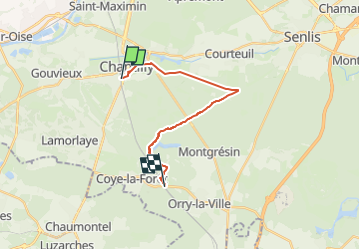
Chantilly Coyes

Jean-Pierre Mena
User

Length
14.8 km

Max alt
89 m

Uphill gradient
157 m
Km-Effort
16.9 km

Min alt
42 m

Downhill gradient
130 m
Boucle
No
Creation date :
2025-05-03 15:52:16.302
Updated on :
2025-05-03 15:52:45.795
3h49
Difficulty : Difficult

FREE GPS app for hiking
 SityTrail
IGN / Geographical institutes
SityTrail Plus
The world is yours!
About
Trail Walking of 14.8 km to be discovered at Hauts-de-France, Oise, Chantilly. This trail is proposed by Jean-Pierre Mena.
Positioning
Country:
France
Region :
Hauts-de-France
Department/Province :
Oise
Municipality :
Chantilly
Location:
Unknown
Start:(Dec)
Start:(UTM)
460651 ; 5448404 (31U) N.
Comments