


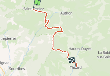
De Saint Geniez à Thoard

laurentnerual
User

Length
24 km

Max alt
1386 m

Uphill gradient
863 m
Km-Effort
36 km

Min alt
710 m

Downhill gradient
1191 m
Boucle
No
Creation date :
2025-05-03 06:49:11.618
Updated on :
2025-05-03 17:52:30.725
10h14
Difficulty : Very difficult

FREE GPS app for hiking
 SityTrail
IGN / Geographical institutes
SityTrail Plus
The world is yours!
About
Trail Walking of 24 km to be discovered at Provence-Alpes-Côte d'Azur, Alpes-de-Haute-Provence, Saint-Geniez. This trail is proposed by laurentnerual.
Description
belle balade, un peu longue , avec une grande descente à la fin
Positioning
Country:
France
Region :
Provence-Alpes-Côte d'Azur
Department/Province :
Alpes-de-Haute-Provence
Municipality :
Saint-Geniez
Location:
Unknown
Start:(Dec)
Start:(UTM)
264658 ; 4903293 (32T) N.
Comments