


CPN

charpe
User
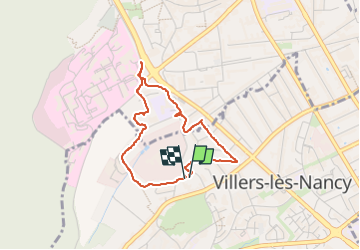

Length
3.1 km

Max alt
268 m

Uphill gradient
46 m
Km-Effort
3.7 km

Min alt
229 m

Downhill gradient
42 m
Boucle
Yes
Creation date :
2025-05-04 08:21:15.0
Updated on :
2025-05-04 09:13:47.08
52m
Difficulty : Easy

FREE GPS app for hiking
 SityTrail
IGN / Geographical institutes
SityTrail Plus
The world is yours!
About
Trail Walking of 3.1 km to be discovered at Grand Est, Meurthe-et-Moselle, Villers-lès-Nancy. This trail is proposed by charpe.
Positioning
Country:
France
Region :
Grand Est
Department/Province :
Meurthe-et-Moselle
Municipality :
Villers-lès-Nancy
Location:
Unknown
Start:(Dec)
Start:(UTM)
289875 ; 5395086 (32U) N.
Comments