


Sentier de la Lande du Don

Ajax44
User
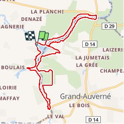

Length
10 km

Max alt
57 m

Uphill gradient
88 m
Km-Effort
11.1 km

Min alt
39 m

Downhill gradient
90 m
Boucle
Yes
Creation date :
2015-07-12 00:00:00.0
Updated on :
2015-07-12 00:00:00.0
2h51
Difficulty : Medium

FREE GPS app for hiking
 SityTrail
IGN / Geographical institutes
SityTrail Plus
The world is yours!
About
Trail Walking of 10 km to be discovered at Pays de la Loire, Loire-Atlantique, Moisdon-la-Rivière. This trail is proposed by Ajax44.
Positioning
Country:
France
Region :
Pays de la Loire
Department/Province :
Loire-Atlantique
Municipality :
Moisdon-la-Rivière
Location:
Unknown
Start:(Dec)
Start:(UTM)
624234 ; 5273560 (30T) N.
Comments