


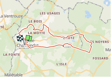
L'Hôme Chamondot 16.87-21288809

togolo28
User

Length
16.9 km

Max alt
276 m

Uphill gradient
226 m
Km-Effort
19.9 km

Min alt
212 m

Downhill gradient
226 m
Boucle
Yes
Creation date :
2025-05-04 12:57:37.076
Updated on :
2025-05-04 12:58:10.265
--
Difficulty : Medium

FREE GPS app for hiking
 SityTrail
IGN / Geographical institutes
SityTrail Plus
The world is yours!
About
Trail Walking of 16.9 km to be discovered at Normandy, Orne, L'Hôme-Chamondot. This trail is proposed by togolo28.
Positioning
Country:
France
Region :
Normandy
Department/Province :
Orne
Municipality :
L'Hôme-Chamondot
Location:
Unknown
Start:(Dec)
Start:(UTM)
331249 ; 5384113 (31U) N.
Comments