


cordes sur ciel

Nancy Arpaia
User
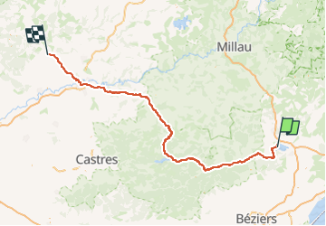

Length
185 km

Max alt
1032 m

Uphill gradient
3155 m
Km-Effort
227 km

Min alt
137 m

Downhill gradient
3042 m
Boucle
No
Creation date :
2025-05-04 13:44:26.122
Updated on :
2025-05-04 14:16:50.594
51h34
Difficulty : Very difficult
0m
Difficulty : Very easy

FREE GPS app for hiking
 SityTrail
IGN / Geographical institutes
SityTrail Plus
The world is yours!
About
Trail Walking of 185 km to be discovered at Occitania, Hérault, Celles. This trail is proposed by Nancy Arpaia.
Positioning
Country:
France
Region :
Occitania
Department/Province :
Hérault
Municipality :
Celles
Location:
Unknown
Start:(Dec)
Start:(UTM)
527035 ; 4834163 (31T) N.
Comments