


GR5-Briançon-Menton - 11

cron
User

Length
20 km

Max alt
2449 m

Uphill gradient
1375 m
Km-Effort
38 km

Min alt
1283 m

Downhill gradient
1140 m
Boucle
No
Creation date :
2017-03-05 00:00:00.0
Updated on :
2017-03-05 00:00:00.0
7h47
Difficulty : Difficult

FREE GPS app for hiking
 SityTrail
IGN / Geographical institutes
SityTrail Plus
The world is yours!
About
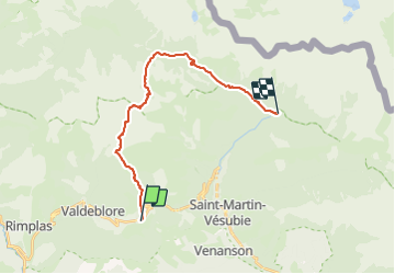
Trail Walking of 20 km to be discovered at Provence-Alpes-Côte d'Azur, Maritime Alps, Valdeblore. This trail is proposed by cron.
Positioning
Country:
France
Region :
Provence-Alpes-Côte d'Azur
Department/Province :
Maritime Alps
Municipality :
Valdeblore
Location:
Unknown
Start:(Dec)
Start:(UTM)
355984 ; 4880817 (32T) N.
Comments