


Le pigeonnier de Sainte-Eulalie

JMJ42
User

Length
13.4 km

Max alt
216 m

Uphill gradient
217 m
Km-Effort
16.3 km

Min alt
103 m

Downhill gradient
218 m
Boucle
Yes
Creation date :
2025-05-05 17:28:56.72
Updated on :
2025-05-05 17:30:18.276
3h42
Difficulty : Difficult

FREE GPS app for hiking
 SityTrail
IGN / Geographical institutes
SityTrail Plus
The world is yours!
About
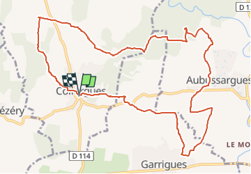
Trail Walking of 13.4 km to be discovered at Occitania, Gard, Collorgues. This trail is proposed by JMJ42.
Positioning
Country:
France
Region :
Occitania
Department/Province :
Gard
Municipality :
Collorgues
Location:
Unknown
Start:(Dec)
Start:(UTM)
603473 ; 4873163 (31T) N.
Comments