


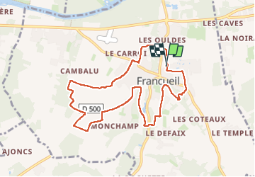
Francueil

Pascal Bernaud
User

Length
9 km

Max alt
111 m

Uphill gradient
121 m
Km-Effort
10.6 km

Min alt
63 m

Downhill gradient
122 m
Boucle
Yes
Creation date :
2025-05-06 07:07:15.0
Updated on :
2025-05-06 09:26:08.539
2h18
Difficulty : Unknown

FREE GPS app for hiking
 SityTrail
IGN / Geographical institutes
SityTrail Plus
The world is yours!
About
Trail Nordic walking of 9 km to be discovered at Centre-Loire Valley, Indre-et-Loire, Francueil. This trail is proposed by Pascal Bernaud.
Positioning
Country:
France
Region :
Centre-Loire Valley
Department/Province :
Indre-et-Loire
Municipality :
Francueil
Location:
Unknown
Start:(Dec)
Start:(UTM)
355222 ; 5241926 (31T) N.
Comments