


Nordique du 10/05/25 Blanchard

explorateur
User
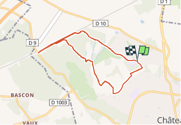

Length
8.5 km

Max alt
222 m

Uphill gradient
101 m
Km-Effort
9.8 km

Min alt
155 m

Downhill gradient
106 m
Boucle
Yes
Creation date :
2025-05-06 12:18:38.314
Updated on :
2025-05-06 15:57:37.925
2h29
Difficulty : Very easy

FREE GPS app for hiking
 SityTrail
IGN / Geographical institutes
SityTrail Plus
The world is yours!
About
Trail Nordic walking of 8.5 km to be discovered at Hauts-de-France, Aisne, Château-Thierry. This trail is proposed by explorateur.
Positioning
Country:
France
Region :
Hauts-de-France
Department/Province :
Aisne
Municipality :
Château-Thierry
Location:
Unknown
Start:(Dec)
Start:(UTM)
528163 ; 5434084 (31U) N.
Comments