


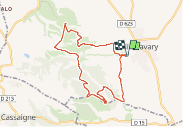
circuit des orchidées

Mascart
User

Length
9.7 km

Max alt
315 m

Uphill gradient
262 m
Km-Effort
13.1 km

Min alt
182 m

Downhill gradient
261 m
Boucle
Yes
Creation date :
2025-05-06 11:35:02.572
Updated on :
2025-05-06 16:06:47.004
3h30
Difficulty : Medium

FREE GPS app for hiking
 SityTrail
IGN / Geographical institutes
SityTrail Plus
The world is yours!
About
Trail Walking of 9.7 km to be discovered at Occitania, Aude, Villasavary. This trail is proposed by Mascart.
Description
boucle à partir du stade de Villasavary
Positioning
Country:
France
Region :
Occitania
Department/Province :
Aude
Municipality :
Villasavary
Location:
Unknown
Start:(Dec)
Start:(UTM)
421571 ; 4785503 (31T) N.
Comments