


jeune

ghislainem
User
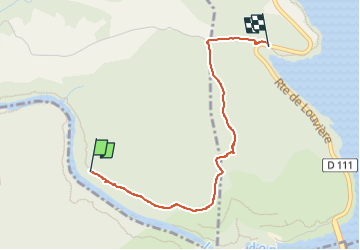

Length
2.9 km

Max alt
559 m

Uphill gradient
91 m
Km-Effort
4 km

Min alt
467 m

Downhill gradient
51 m
Boucle
No
Creation date :
2025-05-07 10:17:57.421
Updated on :
2025-05-07 11:24:47.524
45m
Difficulty : Easy

FREE GPS app for hiking
 SityTrail
IGN / Geographical institutes
SityTrail Plus
The world is yours!
About
Trail Walking of 2.9 km to be discovered at Provence-Alpes-Côte d'Azur, Alpes-de-Haute-Provence, Montagnac-Montpezat. This trail is proposed by ghislainem.
Positioning
Country:
France
Region :
Provence-Alpes-Côte d'Azur
Department/Province :
Alpes-de-Haute-Provence
Municipality :
Montagnac-Montpezat
Location:
Montpezat
Start:(Dec)
Start:(UTM)
267947 ; 4847220 (32T) N.
Comments