


Villelaure 7 mai 2025

rlebasque
User
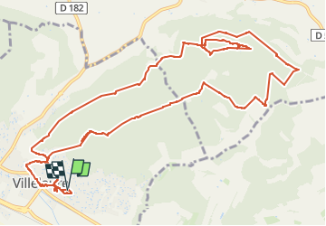

Length
17 km

Max alt
392 m

Uphill gradient
501 m
Km-Effort
24 km

Min alt
180 m

Downhill gradient
502 m
Boucle
Yes
Creation date :
2025-05-07 06:30:36.358
Updated on :
2025-05-07 12:59:06.164
6h27
Difficulty : Very difficult

FREE GPS app for hiking
 SityTrail
IGN / Geographical institutes
SityTrail Plus
The world is yours!
About
Trail Walking of 17 km to be discovered at Provence-Alpes-Côte d'Azur, Vaucluse, Villelaure. This trail is proposed by rlebasque.
Positioning
Country:
France
Region :
Provence-Alpes-Côte d'Azur
Department/Province :
Vaucluse
Municipality :
Villelaure
Location:
Unknown
Start:(Dec)
Start:(UTM)
696521 ; 4842595 (31T) N.
Comments