


Célé Ispanac Marcilhiac

taguette
User
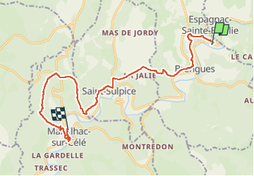

Length
16.4 km

Max alt
316 m

Uphill gradient
521 m
Km-Effort
23 km

Min alt
151 m

Downhill gradient
537 m
Boucle
No
Creation date :
2025-05-07 06:53:28.974
Updated on :
2025-05-07 14:33:13.965
7h39
Difficulty : Very difficult

FREE GPS app for hiking
 SityTrail
IGN / Geographical institutes
SityTrail Plus
The world is yours!
About
Trail Walking of 16.4 km to be discovered at Occitania, Lot, Brengues. This trail is proposed by taguette.
Positioning
Country:
France
Region :
Occitania
Department/Province :
Lot
Municipality :
Brengues
Location:
Unknown
Start:(Dec)
Start:(UTM)
408018 ; 4937609 (31T) N.
Comments