


rando de luzinay

bpc
User
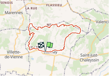

Length
16.4 km

Max alt
358 m

Uphill gradient
333 m
Km-Effort
21 km

Min alt
222 m

Downhill gradient
334 m
Boucle
Yes
Creation date :
2025-05-08 07:01:09.066
Updated on :
2025-05-08 11:12:07.276
3h41
Difficulty : Medium

FREE GPS app for hiking
 SityTrail
IGN / Geographical institutes
SityTrail Plus
The world is yours!
About
Trail Walking of 16.4 km to be discovered at Auvergne-Rhône-Alpes, Isère, Luzinay. This trail is proposed by bpc.
Positioning
Country:
France
Region :
Auvergne-Rhône-Alpes
Department/Province :
Isère
Municipality :
Luzinay
Location:
Unknown
Start:(Dec)
Start:(UTM)
652134 ; 5050228 (31T) N.
Comments