


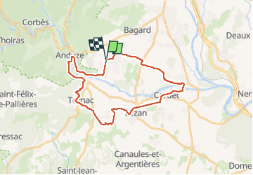
Boisset tornac massillargues cardet

JMJ42
User

Length
31 km

Max alt
179 m

Uphill gradient
363 m
Km-Effort
36 km

Min alt
99 m

Downhill gradient
346 m
Boucle
No
Creation date :
2025-05-08 12:01:37.159
Updated on :
2025-05-08 14:29:02.725
2h04
Difficulty : Difficult

FREE GPS app for hiking
 SityTrail
IGN / Geographical institutes
SityTrail Plus
The world is yours!
About
Trail Mountain bike of 31 km to be discovered at Occitania, Gard, Boisset-et-Gaujac. This trail is proposed by JMJ42.
Positioning
Country:
France
Region :
Occitania
Department/Province :
Gard
Municipality :
Boisset-et-Gaujac
Location:
Unknown
Start:(Dec)
Start:(UTM)
581768 ; 4877792 (31T) N.
Comments