


LLICHEYRE

jeannine grandjean
User
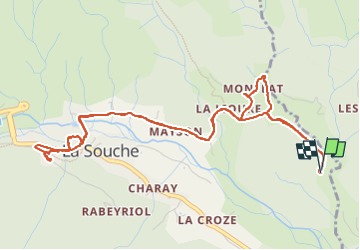

Length
6.3 km

Max alt
585 m

Uphill gradient
157 m
Km-Effort
8.4 km

Min alt
498 m

Downhill gradient
159 m
Boucle
Yes
Creation date :
2025-05-09 13:54:41.0
Updated on :
2025-05-09 15:53:45.038

FREE GPS app for hiking
 SityTrail
IGN / Geographical institutes
SityTrail Plus
The world is yours!
About
Trail of 6.3 km to be discovered at Auvergne-Rhône-Alpes, Ardèche, La Souche. This trail is proposed by jeannine grandjean.
Positioning
Country:
France
Region :
Auvergne-Rhône-Alpes
Department/Province :
Ardèche
Municipality :
La Souche
Location:
Unknown
Start:(Dec)
Start:(UTM)
596750 ; 4942354 (31T) N.
Comments