


sortie vtt du 14072015 n7 pierre percee

fabwin
User GUIDE
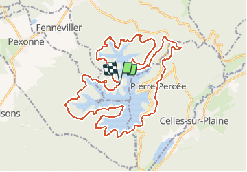

Length
25 km

Max alt
491 m

Uphill gradient
589 m
Km-Effort
33 km

Min alt
374 m

Downhill gradient
588 m
Boucle
Yes
Creation date :
2015-07-14 00:00:00.0
Updated on :
2015-07-14 00:00:00.0
2h38
Difficulty : Unknown

FREE GPS app for hiking
 SityTrail
IGN / Geographical institutes
SityTrail Plus
The world is yours!
About
Trail Mountain bike of 25 km to be discovered at Grand Est, Meurthe-et-Moselle, Badonviller. This trail is proposed by fabwin.
Positioning
Country:
France
Region :
Grand Est
Department/Province :
Meurthe-et-Moselle
Municipality :
Badonviller
Location:
Unknown
Start:(Dec)
Start:(UTM)
345769 ; 5370561 (32U) N.
Comments