


St Cirq la popie Vers

taguette
User
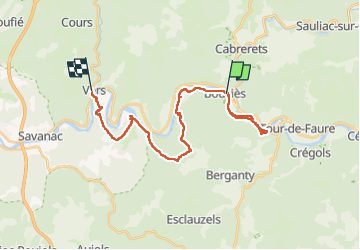

Length
27 km

Max alt
356 m

Uphill gradient
884 m
Km-Effort
39 km

Min alt
120 m

Downhill gradient
881 m
Boucle
No
Creation date :
2025-05-10 06:30:16.754
Updated on :
2025-05-10 14:21:04.082
7h50
Difficulty : Very difficult

FREE GPS app for hiking
 SityTrail
IGN / Geographical institutes
SityTrail Plus
The world is yours!
About
Trail Walking of 27 km to be discovered at Occitania, Lot, Bouziès. This trail is proposed by taguette.
Positioning
Country:
France
Region :
Occitania
Department/Province :
Lot
Municipality :
Bouziès
Location:
Unknown
Start:(Dec)
Start:(UTM)
392164 ; 4926539 (31T) N.
Comments