


Athée-sur-Cher - Chandon - Tour du Brandon - 21.2km 160m 4h40 (50mn) - 2025 05 10

Orcal37
User GUIDE
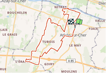

Length
21 km

Max alt
106 m

Uphill gradient
160 m
Km-Effort
23 km

Min alt
51 m

Downhill gradient
159 m
Boucle
Yes
Creation date :
2025-05-10 08:46:51.487
Updated on :
2025-05-11 12:49:54.185
4h40
Difficulty : Easy

FREE GPS app for hiking
 SityTrail
IGN / Geographical institutes
SityTrail Plus
The world is yours!
About
Trail Walking of 21 km to be discovered at Centre-Loire Valley, Indre-et-Loire, Athée-sur-Cher. This trail is proposed by Orcal37.
Description
Athée-sur-Cher - Chandon - Tour du Brandon - variante du PR nommé De la Tour au Château (16km) qui ne passe pas par Chandon - 21.2km 160m 4h40 (50mn) - 2025 05 10
Photos
 - 2025 05 10 - Photo 1")
 - 2025 05 10 - Photo 2")
 - 2025 05 10 - Photo 3")
 - 2025 05 10 - Photo 4")
 - 2025 05 10 - Photo 5")
 - 2025 05 10 - Photo 6")
 - 2025 05 10 - Photo 7")
 - 2025 05 10 - Photo 8")
 - 2025 05 10 - Photo 9")
 - 2025 05 10 - Photo 10")
 - 2025 05 10 - Photo 11")
 - 2025 05 10 - Photo 12")
Positioning
Country:
France
Region :
Centre-Loire Valley
Department/Province :
Indre-et-Loire
Municipality :
Athée-sur-Cher
Location:
Unknown
Start:(Dec)
Start:(UTM)
342699 ; 5243534 (31T) N.
Comments