


11_5_25

baudon
User
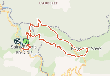

Length
13.1 km

Max alt
1000 m

Uphill gradient
737 m
Km-Effort
23 km

Min alt
348 m

Downhill gradient
738 m
Boucle
Yes
Creation date :
2025-05-11 06:43:27.831
Updated on :
2025-05-11 11:41:45.058
4h56
Difficulty : Very difficult

FREE GPS app for hiking
 SityTrail
IGN / Geographical institutes
SityTrail Plus
The world is yours!
About
Trail Walking of 13.1 km to be discovered at Auvergne-Rhône-Alpes, Drôme, Saint-Benoit-en-Diois. This trail is proposed by baudon.
Positioning
Country:
France
Region :
Auvergne-Rhône-Alpes
Department/Province :
Drôme
Municipality :
Saint-Benoit-en-Diois
Location:
Unknown
Start:(Dec)
Start:(UTM)
680119 ; 4948068 (31T) N.
Comments