


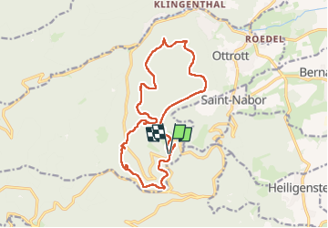
Le circuit des 5 châteaux

VacheKiri67
User


5h02
Difficulty : Medium

FREE GPS app for hiking
 SityTrail
IGN / Geographical institutes
SityTrail Plus
The world is yours!
About
Trail Walking of 16.1 km to be discovered at Grand Est, Bas-Rhin, Ottrott. This trail is proposed by VacheKiri67.
Description
Faite le 11/05/2025. D'après "Passion Vosges : Mont Sainte-Odile - 6 : Le circuit des 5 châteaux". Durée indiquée pour le circuit : 5h30. Départ parking III (inférieur) du Mont Sainte-Odile.
Photos


25 photos in total. Please click on a photo to see them all in the gallery.
Positioning
Comments