


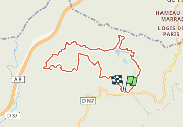
FREJUS-Lac et le Vallon de Lavelan-Piste de l'Esquine

ripoll dominique
User

Length
9.7 km

Max alt
314 m

Uphill gradient
271 m
Km-Effort
13.3 km

Min alt
68 m

Downhill gradient
270 m
Boucle
Yes
Creation date :
2025-05-11 14:29:50.022
Updated on :
2025-05-11 14:38:19.939
3h02
Difficulty : Medium

FREE GPS app for hiking
 SityTrail
IGN / Geographical institutes
SityTrail Plus
The world is yours!
About
Trail Walking of 9.7 km to be discovered at Provence-Alpes-Côte d'Azur, Var, Fréjus. This trail is proposed by ripoll dominique .
Description
Parking et départ de la randonnée : Col du Testanier
COORD GPS :43.019,6.7938
Positioning
Country:
France
Region :
Provence-Alpes-Côte d'Azur
Department/Province :
Var
Municipality :
Fréjus
Location:
Unknown
Start:(Dec)
Start:(UTM)
321663 ; 4818919 (32T) N.
Comments