


baratier. 2025.05.12

trusgnachjf
User
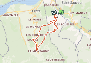

Length
17.2 km

Max alt
1577 m

Uphill gradient
732 m
Km-Effort
27 km

Min alt
954 m

Downhill gradient
730 m
Boucle
Yes
Creation date :
2025-05-12 06:45:14.857
Updated on :
2025-05-12 15:11:25.256
8h24
Difficulty : Very difficult

FREE GPS app for hiking
 SityTrail
IGN / Geographical institutes
SityTrail Plus
The world is yours!
About
Trail Walking of 17.2 km to be discovered at Provence-Alpes-Côte d'Azur, Hautes-Alpes, Baratier. This trail is proposed by trusgnachjf.
Positioning
Country:
France
Region :
Provence-Alpes-Côte d'Azur
Department/Province :
Hautes-Alpes
Municipality :
Baratier
Location:
Unknown
Start:(Dec)
Start:(UTM)
301394 ; 4933340 (32T) N.
Comments