


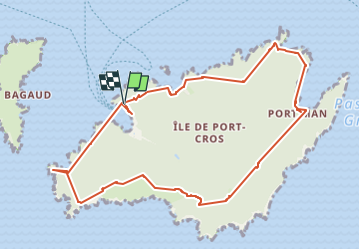
Port Cros 13 mai 2025

rlebasque
User

Length
11.5 km

Max alt
198 m

Uphill gradient
591 m
Km-Effort
19.3 km

Min alt
0 m

Downhill gradient
585 m
Boucle
Yes
Creation date :
2025-05-13 08:00:32.702
Updated on :
2025-05-13 14:17:36.925
6h14
Difficulty : Very difficult

FREE GPS app for hiking
 SityTrail
IGN / Geographical institutes
SityTrail Plus
The world is yours!
About
Trail Walking of 11.5 km to be discovered at Provence-Alpes-Côte d'Azur, Var, Hyères. This trail is proposed by rlebasque.
Positioning
Country:
France
Region :
Provence-Alpes-Côte d'Azur
Department/Province :
Var
Municipality :
Hyères
Location:
Unknown
Start:(Dec)
Start:(UTM)
286667 ; 4765257 (32T) N.
Comments