


sortie 13x05x25

Didier-114
User
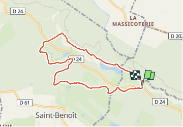

Length
8.2 km

Max alt
181 m

Uphill gradient
98 m
Km-Effort
9.5 km

Min alt
123 m

Downhill gradient
99 m
Boucle
Yes
Creation date :
2025-05-13 11:55:59.65
Updated on :
2025-05-13 14:37:14.078
2h40
Difficulty : Medium

FREE GPS app for hiking
 SityTrail
IGN / Geographical institutes
SityTrail Plus
The world is yours!
About
Trail Walking of 8.2 km to be discovered at Ile-de-France, Yvelines, Cernay-la-Ville. This trail is proposed by Didier-114.
Positioning
Country:
France
Region :
Ile-de-France
Department/Province :
Yvelines
Municipality :
Cernay-la-Ville
Location:
Unknown
Start:(Dec)
Start:(UTM)
422133 ; 5392608 (31U) N.
Comments