


schnappsbrunnenweg

anniston
User
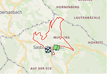

Length
8.5 km

Max alt
456 m

Uphill gradient
320 m
Km-Effort
12.7 km

Min alt
211 m

Downhill gradient
323 m
Boucle
Yes
Creation date :
2025-05-08 09:14:20.308
Updated on :
2025-05-13 22:58:09.963
2h21
Difficulty : Difficult

FREE GPS app for hiking
 SityTrail
IGN / Geographical institutes
SityTrail Plus
The world is yours!
About
Trail Walking of 8.5 km to be discovered at Baden-Württemberg, Ortenaukreis, Sasbachwalden. This trail is proposed by anniston.
Positioning
Country:
Germany
Region :
Baden-Württemberg
Department/Province :
Ortenaukreis
Municipality :
Sasbachwalden
Location:
Unknown
Start:(Dec)
Start:(UTM)
435891 ; 5385128 (32U) N.
Comments