


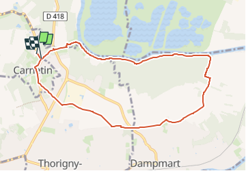
Carnetin, forêt des Vallières

Randos du mercredi
Le mercredi c'est rando

Length
8.7 km

Max alt
126 m

Uphill gradient
124 m
Km-Effort
10.4 km

Min alt
39 m

Downhill gradient
125 m
Boucle
Yes
Creation date :
2025-05-14 07:40:55.41
Updated on :
2025-05-14 07:42:56.495
2h21
Difficulty : Medium

FREE GPS app for hiking
 SityTrail
IGN / Geographical institutes
SityTrail Plus
The world is yours!
About
Trail Walking of 8.7 km to be discovered at Ile-de-France, Seine-et-Marne, Carnetin. This trail is proposed by Randos du mercredi.
Description
Sortie du 21 Mai 2025
Parking : Cimetière de Carnotin
Positioning
Country:
France
Region :
Ile-de-France
Department/Province :
Seine-et-Marne
Municipality :
Carnetin
Location:
Unknown
Start:(Dec)
Start:(UTM)
478444 ; 5416754 (31U) N.
Comments