


Trace Dentelle Montmirail G3Guy

mitch1952
User
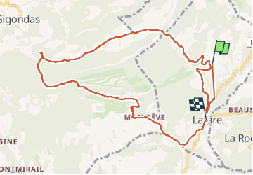

Length
12.6 km

Max alt
468 m

Uphill gradient
445 m
Km-Effort
18.7 km

Min alt
147 m

Downhill gradient
500 m
Boucle
No
Creation date :
2025-05-14 07:16:22.0
Updated on :
2025-05-14 12:43:45.95

FREE GPS app for hiking
 SityTrail
IGN / Geographical institutes
SityTrail Plus
The world is yours!
About
Trail of 12.6 km to be discovered at Provence-Alpes-Côte d'Azur, Vaucluse, Lafare. This trail is proposed by mitch1952.
Positioning
Country:
France
Region :
Provence-Alpes-Côte d'Azur
Department/Province :
Vaucluse
Municipality :
Lafare
Location:
Unknown
Start:(Dec)
Start:(UTM)
664154 ; 4891284 (31T) N.
Comments