


theux cimetiere

BoulangerPierre
User GUIDE
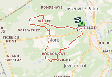

Length
7.6 km

Max alt
323 m

Uphill gradient
190 m
Km-Effort
10.1 km

Min alt
190 m

Downhill gradient
198 m
Boucle
No
Creation date :
2025-05-14 11:30:58.486
Updated on :
2025-05-14 13:47:04.847
2h15
Difficulty : Medium

FREE GPS app for hiking
 SityTrail
IGN / Geographical institutes
SityTrail Plus
The world is yours!
About
Trail Walking of 7.6 km to be discovered at Wallonia, Liège, Theux. This trail is proposed by BoulangerPierre.
Positioning
Country:
Belgium
Region :
Wallonia
Department/Province :
Liège
Municipality :
Theux
Location:
Theux
Start:(Dec)
Start:(UTM)
698681 ; 5601991 (31U) N.
Comments