


2025-05-14 après midi 01
© OpenStreetMap contributors


31m
Difficulty : Easy


Length
3.2 km
Max alt
39 m
Uphill gradient
14 m
Km-Effort
3.4 km
Min alt
30 m
Downhill gradient
9 m
Boucle
No
Creation date :
2025-05-14 14:23:51.0
Updated on :
2025-05-14 14:55:32.059
31m
Difficulty : Easy
FREE GPS app for hiking
 SityTrail
IGN / Geographical institutes
SityTrail Plus
The world is yours!
About
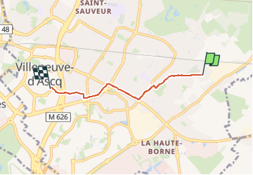
Trail Walking of 3.2 km to be discovered at Hauts-de-France, Nord, Villeneuve-d'Ascq. This trail is proposed by 001176.05285939d7c848918be5cbf93d931c37.0558.
Positioning
Country:
France
Region :
Hauts-de-France
Department/Province :
Nord
Municipality :
Villeneuve-d'Ascq
Location:
Unknown
Start:(Dec)
Start:(UTM)
512031 ; 5607479 (31U) N.
Comments